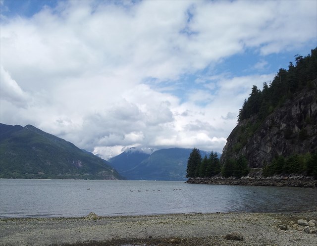
*The posted coordinates bring you to a lookout along the pier where you can make your observations.
The pier is completely wheelchair accessible.*
Human History
Porteau Cove (French for water gate) or Xwáxw’chayay as it is known to the Squamish First Nation has been an important hunting and gathering area for 9800 years BP, known for its rich seafood and deer population. Xwáxw’chayay is the name for the sturgeon that was fished from this area. The first European settlement was in 1908 when John Deeks began mining sand and gravel deposits. The settlement included housing, a schoolhouse and tennis courts. The Union Steamship Company provided daily ferry service that ran from Vancouver to Squamish. The settlement was abandoned in 1930. The current pier is designed as an emergency ferry landing in case a catastrophic landslide closes the highway for any length of time. Highway 99 was completed to Britannia in 1958 and Squamish in 1959. It is a testament to the attempts of humans to control their environment. Today Porteau Cove is a Provincial Park with a campground and other amenities. It is a popular location for diving due to the shallow water and artificial reefs.
The original highway was a two lane road clinging to the side of the steep mountains, just above the rail line. It was narrow, winding, and deadly. Steep slopes are prone to debris flows that originate in the mountains high above and come thundering down, washing out bridges, homes, and anything else in their paths. You will have noticed concrete debris chutes along the highway that attempt to control this flow. The other factor is that the bedrock in the area is full of cracks. Water and freeze/thaw combinations have led to sudden rock falls on to the highway. Much engineering has made these rock faces more stable by drilling bolts to attach the cracks, and drilling holes for water to drain. One of the lasting legacies of the 2010 Winter Olympics was the multi billion dollar reconstruction of pretty much the entire route.
Geology of the Area
Howe Sound, and the nearby Indian Arm are the southernmost coastal fjords in North America. The coast line of British Columbia has a large number of fjords that are the deeply eroded old river valleys that mark the path of outlet glaciers of the Cordilleran ice sheets. Howe Sound is the only one that you can drive the entire length of. Looking at a map of British Columbia shows many of these fjords that extend as much as 150 km inland and can be up to 750 M deep. The Squamish River is the origin of the Howe Sound fjord.
Fjords are essentially drowned valleys. Glaciation created a typical U shaped valley. The glaciers retreated, the land rebounded and sea level rose, creating a steep walled inlet. As typical of glaciation, a terminal moraine was created ahead of the toe of the glacier between 13,000 and 15,000 years ago as the ice pushed sand, gravel and boulders ahead of its path. This moraine, a broad ridge of sand and gravel spreads across Howe Sound at Porteau Cove. At points it is only 30M below sea level where the surrounding sea floor is around 200M. As is typical of many fjords, the sea depth behind the moraine is deeper than the surrounding sea due to the glaciers retreating faster than sea level rose.
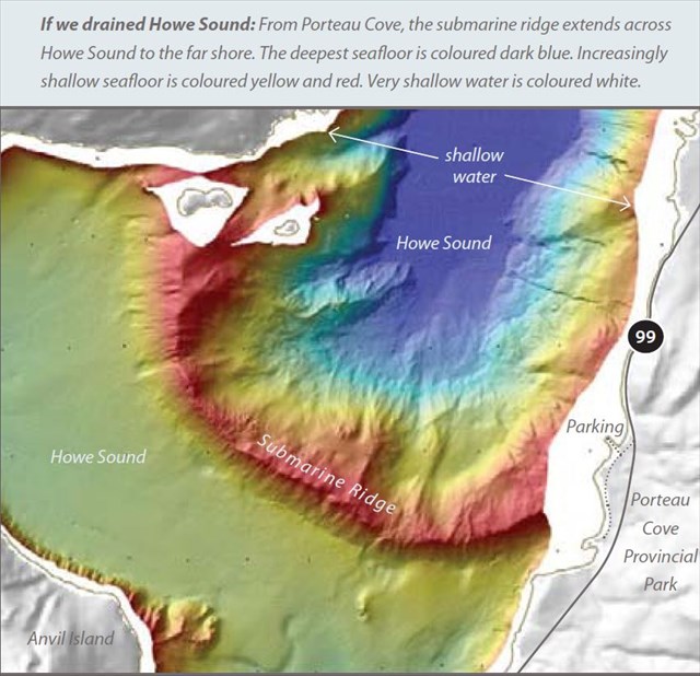 graphic courtesy Natural Resource Canada
To Log This Earthcache
Please send me answers to the following questions to my profile on geocaching.com. Any logs without follow-up answers will be deleted as required by the Earthcache program.
1. The posted coordinates will bring you to a lookout on the pier facing south.
a) What is the name of the island to your right? Hint – read the interpretive plaques along the pier. Bonus if you can give the First Nations name as well.
b) Do the islands and surrounding areas show a gentle or steep slope towards the sea?
c) From the glaciation processes, you have learned what causes the shallow water in the sea at this location. Can you describe something you see in the park that confirms this?
d) (Optional) At certain times of the day you may hear a whistling sound close to where you are standing. What is the source and the cause? An explanation of the cause is on one of the interpretive boards.
2. Turn around to face towards the highway. You should clearly see why it is called the “Sea to Sky”.
a) How much room would you estimate is between the highway and the mountains at this location?
b) Estimate the height of the mountain peak you see high above the highway (give it a good guess at least).
c) Typically fjords have steep sides. Would you estimate the angle of the mountain peak above to be steeper than 45 degrees or less steep from this location?
Feel free to post pictures of your visit to the Earthcache!
References
Sea to Sky Geotour, Natural Resources Canada www.SeaToSky.nrcan.gc.ca
Vancouver, City on the Edge, Clague, John & Turner, Bob Tricouni Press, 2010
LM
