The river's source is a series of swamps in the upper reaches of the Yarra Ranges National Park, directly to the west of the Mount Baw Baw plateau, a thickly forested sub-alpine park, which is entirely closed-off to all except the employees of Melbourne Water. The park features extensive stands of mountain ash, a very tall eucalypt, tree ferns, as well as patches of remnant rainforest.
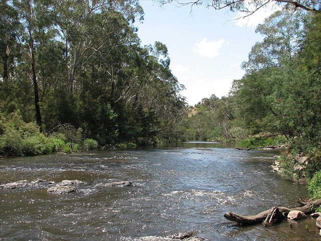
The Upper Yarra Dam, one of a number of dams in the Yarra Catchment that supply a large part of Melbourne's water, is the furthest upstream point on the river visible to the general public (though the dam itself is closed off). The first settlement the still-young river passes through is the small town of Reefton, but most of the river is surrounded by hills covered with temperate forest until the timber and resort town of Warburton. The Woods Point Rd follows the river through this section.
Downstream of Warburton, the Yarra Valley is made up of two soil types, silurian mudstone/sandstone sediments and basalt derived soils. The basalts originated from two separate volcanic lava flows. The first filled the ancestral Merri Creek Valley approximately 2.2 million years ago. The second flowed down the valley of Darebin creek and into the Yarra Valley around 800,000 years ago.
The Merri and Darebin creeks managed to re-establish their flow across the basalt, however the Yarra was blocked, producing a lake and broad floodplain upstream of Kew. Eventually the Yarra began to cut a new course between the basalt and uplifted silurian mudstone/sandstone sediments which dominate the southern end of the floodplain region. The current course of the river meanders with very steep outer sides and gentler slopes on the inner sides.
Recently, earth has been deposited on the gentle slopes but this is currently being eroded as the Yarra River continues to carve its displaced bed. The colloidal material being picked up in this way is what gives the Yarra its characteristic brown colour in the lower reaches towards and through the urban area of Melbourne.
The river enters Melbourne's suburbs proper at Chirnside Park, but virtually all the river's length is surrounded by parkland, much retaining (or having been replanted with) extensive native vegetation. A bicycle and walking trail known as the Main Yarra Trail begins at Warrandyte and becomes the Yarra River Trail, and in the lower reaches, the Capital City Trail. The river is used extensively for kayaking at Templestowe, and canoes can often be seen throughout the suburban section. The muddy appearance does not mean that the Yarra is unclean. In fact, it is probably one of the cleanest capital city rivers in the world. Since the major clean-up campaigns of the late 1970s and 1980s, the river has again become home to platypus and a range of migratory native fish species. Platypus have been sighted in the Yarra River at Kew, less than 10 km from the city centre.
The river's ancient delta meant that the land between St Kilda and Williamstown was mostly swamp. As such the city of Melbourne was initially established on the higher northern bank. The low, flat land on the southern bank was largely left to light industrial development until late in the 20th century. Albert Park Lake is the last remnant of those delta swamps.
Below Dights Falls at Yarra Bend Park in inner Melbourne, the river becomes increasingly estuarine as it passes along the southern side of the central business district. This area forms the venue for the annual "Moomba" festival, which notably features an annual water skiing competition which attracts a huge crowd. The lower stretch of the river from Docklands to the Melbourne Cricket Ground was part of the final path of the Queen's Baton Relay of the 2006 Commonwealth Games. Many of Melbourne's private schools, located close to the river, train their rowing crews on it.
The lower reaches feature a number of boat cruises, using especially low-roof boats to go under the many bridges across this section of the Yarra. Herring Island is a small island at South Yarra which has a punt which takes people on to the park. The area in front of old Customs House is a former turning basin for ships. It is the point which was once known as "Freshwater Place" and once had a set of cascades which prevented both salt water and larger ships from going further upstream. This series of rocks, originally used to cross the river, and referred to as the "Yarra Falls" was removed using explosives and divers in 1883.

The final section passes through the Port of Melbourne and under the Bolte Bridge and the West Gate Bridge. The current course dates back to 1886 when a canal devised by British engineer Sir John Coode was cut from west of Flinders Street to below its junction with the Maribyrnong. The resulting island between the new and old courses of the river was named Coode Island, , and is now part of the mainland with the former course to the north filled in. The river flows into Port Phillip, the site being extensively altered as part of the Port of Melbourne, Australia's busiest seaport.
Near the coordinates given above, and on the far bank east of the White Arched pedestrian bridge, you can take a ferry up the river for a short distance, or out through the mouth to Williamstown in Port Phillip Bay.
About 30-40m to the west of the given location, you will find a very informative and interesting information panel in glass at this end of the Sandridge Bridge. The panel is titled "Meeting Place". The information it contains will help you to answer the questions below. The bridge is an interesting feature in its own right, telling the story of the migration of people here from a number of other countries.
Requirements for Permission to log a find on the Earthcache
Note: It's quite okay to log an earthcache find immediately, so that your order of finds is preserved, but I must receive your answers with a week to ten days, or your log may be deleted.
Q1. Prior to development of this area, there was a rocky ledge and waterfall just along where the Queens Street Bridge is today. What two sections of the river do you think this waterfall separated?
Q2 With the knowledge gained from reading the information above, how clean does the water look to you? Would you go for a swim if there was no river traffic?
Q3 Now Compulsory - please attach a photo of yourself, or a personal item, with the river in the background, to your Find log.
Email your answers to me at earthcaches@jamieson.id.au . This is important as it will go directly to my phone and I can respond immediately. Emails to my geocaching.com account will be responded to eventually, but could get temporarily lost in my watchlist emails.