To log your visit
Email us through our profile (Email, not the message centre, thanks) the answers to the following logging requirements:-
1. At N53 00.363 W006 22.090 describe the landscape you see before you.
2. At N53 00.371, W006 22.415, Along this section of the path there is an information board. According to the information provided, What are the 2 main rock types in this valley? and what did the miner's prospecting in the 19th century find deposits of?
3. At N53 00.360 W006 22.336, As per the description above, the valley was formed during the last ice age by a glacier which left a moraine across the valley mouth. Tell me what type of moraine you think it is and why.
4.At N53 00.398, W006 23.044 (given co-ords), estimate the height and width of this glacial boulder. Which type of glacial erosion do you think caused this boulder to be here and why.
The following is optional and NOT a requirement to log your visit - Feel free to upload any photos you take during your visit to the earthcache site providing they don't give away the answers to the logging requirements.
Do not wait to log your find. As soon as you have emailed the answers via our profile, please log the cache as found. Note: You will be contacted if no answers are received or if there are any issues with your answers.
This Earthcache brings you on a walk on the path along the upperlake to just past the miner's village were you will gather information along the way for the logging requirements of this Earthcache with the last .2 of a mile over uneven ground giving the 3 star terrain rating.
Also, the following notice is in place on the trail as of the time this earthcache was published so please exercise caution.
NOTE: Walkers are advised that following recent flooding, the Miners' Road is in very poor condition in places. Walkers are asked to take care while repair work is on going. We apologise for any inconvenience.
Waypoint provided to the Upper Lake car park which is closest to the starting point of the walk. It costs €4 to park in. I have provided a waypoint for the Glendalough Visitors Centre car park which is free of charge. It is further away (1.5km) from the starting point, but it takes in a beautiful walk past the lower lake. The Visitor Centre has an interesting exhibition and an audio-visual show.
Opening Hours :
Mid October - Mid March: Daily 9.30 - 17.00
Mid March - Mid October: Daily 9.30 - 18.00
Admission Fees :
E Adult: €3.00
Sen/Group: €2.00
Child/Student: €1.00
Family: €8.00
NOTE: The weather varies rapidly in the National Park. The phrase ‘four seasons in one day’ often applies so come prepared!
IMPORTANT:
You undertake to seek out this Earthcache at your own risk.
Neither the Earthcache developer, AbbeyAckbar, or the landmanagers of Glendalough will be responsible for any accident, injury or loss to people or their belongings while locating this Earthcache. Please exercise due caution.
Also please adhere to the principles of Leave No Trace outdoor ethics :
1. Plan ahead
2. Dispose of waste properly
3. Be considerate of others
4. Respect wildlife
5. Leave what you find
6. Travel and camp on durable ground
7. Minimise the effects of fire.
This Earthcache was developed with the support of the National Parks and Wildlife Service.
To find out more about Glendalough follow this link :
Wicklow Mountains National Park
GLENDALOUGH
Glendalough Valley is located in County Wicklow, Ireland.
It is an area of exceptional natural beauty.
The name Glendalough comes from the Irish Gleann Dá Locha, which means Valley of the Two Lakes.
Glendalough is a glacial valley located in the Wicklow Mountains National Park, and this EarthCache was developed to explain how it was formed.
~~~~~~
The Wicklow Mountains
Millions of years ago (approx 500million : ) ) Ireland as it is today did not exist.
The land that would form Ireland was beneath the Iapetus Ocean (a predecessor to the Atlantic Ocean we know today). Great amounts of material from volcanic eruptions and landslides were deposied on this ocean floor. The weight of this material on the lower level deposits compressed it into rock. When the continental plates of North America and Europe collided (approx. 420 million years ago), the land beneath the sea was forced upward. This land rose out of the sea, forming the Wicklow Mountains.
Mining for minerals was a big industry in the Wicklow Mountains for approx. 150 years. The formation of these minerals is tied in with the process of the rock formation. The point where the different rock types were forming side by side would have been a superheated soup of minerals. Quartz rock formed between these rocks and minerals gathered in veins within the quartz.
Over millions of years of erosion from Ice, wind and water, the mountains were shaped into the rounded hills we have today.
~~~~~~
Ireland owes the physical shape of its landscape almost entirely to the actions of the last Ice Age of 20,000 to 10,000 years ago.
Glacial landforms are those created by the action of glaciers.
Glaciers are a large body of persistent ice.
Originating on land, a glacier flows slowly due to stresses brought on by its weight. As the glaciers grew bigger, due to their accumulating weight of snow and ice, they crushed and scoured surface rocks and bedrock.
Slowly the ice started to melt (Slowly meaning really slow as it took at least 10,000 years!, give and take a few thousand). Rivers and lakes formed in the new landforms left by the glaciers, which is the case with the 2 resulting lakes at Glendalough.
To further understand how the glacier acted upon the landscape, you must first learn a little about glacial erosion.
Glacial Erosion
There are three main types of glacial erosion - plucking, abrasion and freeze thaw. Below is a diagram to help explain this.
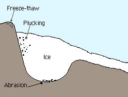
Plucking
As the glacier flows over the bedrock's fractured surface, it softens and lifts blocks of rock that are brought into the ice. This process is known as Plucking.
Abrasion
Abrasion occurs when the ice and the load of rock fragments slide over the bedrock and function as sandpaper that smoothes and polishes the surface situated below.
Freeze-thaw
Freeze-thaw is when melt water or rain gets into cracks in the bed rock, usually the back wall. At night the water freezes, expands and causes the crack to get larger. Eventually the rock will break away.
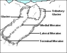
Obvious impacts of the ice on the landscape include the formation of glacial valleys, such as Glendalough. The valley was formed during the last ice age by a glacier which left a moraine across the valley mouth.
Moraine
This is any glacially formed build up of loose glacial debris (soil and rock) which can occur in currently glaciated and formerly glaciated areas, like those regions acted upon by a previous ice age. This debris may have been plucked off the valley floor as a glacier moved along or it may have fallen off the valley walls as a result of frost wedging or landslide. Moraines can be made up of debris ranging in size from silt-sized glacial flour to large boulders.
Moraine Types
There are various types of moraines including medial, lateral and terminal moraines.
Medial moraine: A medial moraine is a ridge of moraine that runs down the center of a valley floor. It is formed when two glaciers meet and the debris on the edges of the adjacent valley sides join and are carried on top of the enlarged glacier. As the glacier melts or retreats, the debris is deposited and a ridge down the middle of the valley floor is created.
Lateral moraine:Lateral moraines are parallel ridges of debris deposited along the sides of a glacier.
Terminal/End moraines:End moraines, or terminal moraines, are ridges of unconsolidated debris deposited at the snout or end of the glacier.
Below is a diagram to help explain this.
~~~~~~
The Lakes at Glendalough
The Poulanass river, which plunges into the valley from the south, created a delta, which eventually divided the original lake in two.
Delta
A delta is a landform that is formed at the mouth of a river where that river flows into an ocean, sea, estuary, lake, reservoir, flat arid area, or another river. Deltas are formed from the deposition of the sediment carried by the river as the flow leaves the mouth of the river. Over a long period of time at Glendalough the sediment built up and the original lake was divided into two.
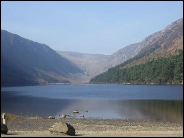 Upper Lake - Glendalough
Today, the majestic landscape of Glendalough is there for everyone to enjoy. There are many walking trails of varying difficulty around Glendalough. Within the valley itself there are nine colour-coded walking trails maintained by Wicklow Mountains National Park. The walks vary in length and difficulty. Large maps of the walks are displayed at the Visitor Centre and on the Notice Board at the Upper Lake car park. There is an information office located near the carpark at the Upper Lake which can provide you with further information.
 HAPPY EARTHCACHING!
| I am a proud |
 |