Turkey and Cheddar Folds EarthCache
-
Difficulty:
-

-
Terrain:
-

Size:  (not chosen)
Please note Use of geocaching.com services is subject to the terms and conditions
in our disclaimer.
This EarthCache is on State Trust Land. The State Land Department
has no problem with EarthCaching, however, a Recreation Permit is
required to legally access State Trust Land. These permits are
easily obtained by phoning (602) 364-ASLD. This is a recording in
which people can request a permit application. The permits are
relatively inexpensive - $15 for an Individual Permit, and $20 for
a Family Permit. The permits are good for one year from the date of
issue, and allow legal access to any State Trust Land in
Arizona.
While out on a recent ”Jeeping” trip, some friends of mine were
asking me about the strange folds in the rocks we were seeing as we
were driving and hiking. Like many people, they were curious about
how rocks (which are so hard) could become so deformed. Since we
were eating lunch, and since I had the makings of a turkey sandwich
handy, I decided to illustrate the concept of folding with my food.
At the time, I had turkey and swiss, but the contrast between the
two is pretty poor in photos. Therefore, for the pictures in this
EarthCache, I have decided to use turkey and cheddar…
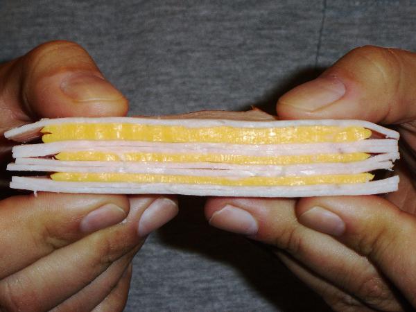
The Sediments
The folded rocks at the posted coordinates began life as
sedimentary rocks about 1.6 to 1.8 billion years ago. They were
laid down, horizontally, as sediments (see picture 1) and were
eventually buried. Over time, they were also buried by many miles
of additional sediments and volcanic rocks.
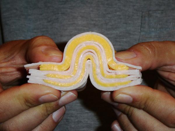
The Pressure/Heat/Stress
The buried sediments/layers were then subjected to pressure from
the overlying rocks, and heat from being at depth and other
geologic activity in the area over time. The heat and pressure
softens the rock slightly and makes it pliable (or ductile).
Stresses from the movement of the ground (plate tectonics) pushed
on the rock layers and folded them up (see picture 2). You will
note in the picture that that the primary stresses are induced from
my left and right hands as they push toward one another.

The Resulting Fold
At the site, you will notice the large, obvious fold structure
right away. It will look very much like picture 3.
If you take a little time and look around the area, you will see
many more fold structures and even folds within folds. This area
was, at one time, subjected to a lot of stress and that, in turn,
produced the strain that we see as folded layers within the rock.
Over time, additional geologic activity and erosion brought the
folds to the surface where you see them today.
There are many types of folds and they may be very small, or very
large (spanning many kilometers). One of the fields of study for
identifying and understanding folds is “Structural Geology”.
Logging the EarthCache
In order to log this cache, you must do two simple things:
1) Post a picture (with your log) of you and your GPS in front of
the large fold structure you see at the posted coordinates and,
2) In an e-mail (do NOT post in your log), tell me from what
compass direction the opposing strain apparently came. Your answer
will involve two directions, for example “North/South” or
“Northwest/Southeast”. Please also include the number of people in
your party and please include the cache title "Turkey" in the
subject line.
A bonus question, for you overachievers: “What TYPE and CLASS of
fold is the large fold at the posted coords?” If you like, you may
include your answer in your e-mail when you tell me the two
directions from which the opposing stresses came.
Geology is a fun and interesting subject for me, and I enjoy
sharing it with others. I hope you enjoyed this opportunity to
learn more about folds and will appreciate the forces that made
them. As always, please stay on marked trails, take only pictures
and memories, and leave only footprints. Practice CITO too!
Acknowledgments
I’d like to thank Dr. Stephen Reynolds and PhD candidate Joshua
Coyan for being my instructors and mentors when I studied
structural geology at Arizona State University.
References
Davis, George H., and Reynolds, Stephen J., 1996, Structural
Geology of Rocks and Regions, 2nd edition: John Wiley & Sons,
Inc., New York, New York, 776p.
Reynolds, S.J., 1988, Geologic Map of Arizona: Arizona Geological
Survey Map 26, scale 1:1,000,000.


Additional Hints
(No hints available.)